Brandenberg

Brandenburg

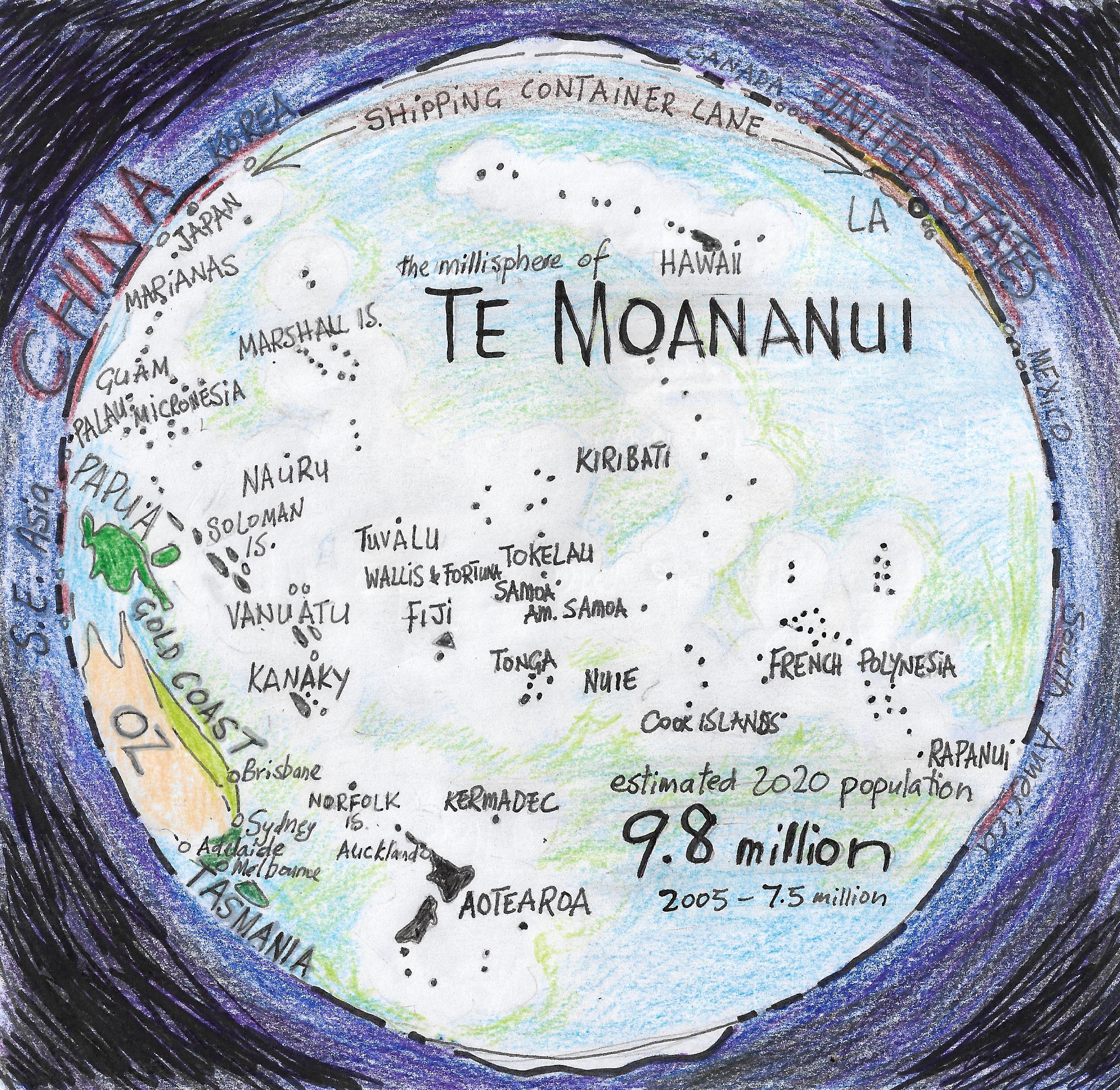
Millisphere: a discrete region inhabited by approximately one thousandth of the world population – around eight million people.

The millisphere of Brandenburg (the Berlin/Brandenburg metropolitan region: six million people) came to my attention when Holly (born and raised in Whanganui) bailed from Berlin and repatriated to Whanganui.

“Why did you leave Berlin?” I had asked her. “After the baby was born everything changed”. Instead of the party scene that drew young people from all over the world lockdown with a newborn wasn’t as much fun; besides, “poor but sexy” Berlin was rapidly gentrifying and even before Covid the young international set were heading for cheaper cities like Leipzig, Warsaw and Lubyanka in Europe and Mexico City and Sao Paulo in the Americas.

In the middle ages Berlin was on the east/west trade route roughly where Europe divided from Frankish to Slavic. In the sixteenth century Berlin went Lutheran and half of the population was killed during the Thirty Years War (1618-48) which started as a conflict between German protestants and catholics.

Berlin became the Prussian capital, German states unified and Berlin became the capital of the “German Empire” and in the twentieth century Prussia was subsumed into Adolf Hitler’s “Third Reich”.

Under the Nazis “the mother of all airports” was built at Tempelhof, outside Berlin. Hitler’s architect Albert Speer’s megalomaniac vision for the “world city of Germania” was made manifest at Tempelhof. Pre WWII Tempelhof was the world’s busiest airport. With huge arc shaped hangers it has been described as the “one of the really great buildings of the modern age”. Tempelhof ceased operating in 2008 and today is used as a recreation zone and recently a refugee camp for Syrians.

During the Cold War West Berlin found itself an island in Soviet Russian controlled territory and when the communists closed all land access West Germany was faced with the choice of abandoning Berlin or supplying it by air. Tempelhof became the destination for the Berlin Airlift and by 1954 was the 3rd busiest in Europe. The fall of the Berlin wall in 1989 spelled the end of Tempelhof which was replaced with a modern airport with longer runways at Brandenburg.

During the cold war West Berlin suffered economically from regional isolation and from 1979-81 self organised squatter communities occupied abandoned apartment blocks. Starting with DIY reconnections of water and electricity, then knocking out walls and reconfiguring architecture, by 1981 there were 168 houses occupied creating a large and vibrant counterculture scene – and conflict with authority. Evictions were met with protests but some 77 squats secured contracts to occupy.

In 1988, a year before the fall of the wall, squatters occupied a piece of bare land which was technically in East Berlin but the wall had been built in the wrong place and in 1989-90 “black living” moved into East Berlin proper. Because people were excluded the east/west border had become a nature corridor.

Since German reunification the capital moved from Bonn back to Berlin. Property speculators piled in to take advantage of the boom and worked with police to evict the squatters “keeping Berlin weird” and gentrified the old apartment blocks. Berlin, like many western cities, now suffers from the lack of affordable housing and in 2017 prices increased faster than any “world city’.

Brandenburg is low lying and flat with chains of lakes and forests that make it very beautiful. The villages and towns in the old East Germany have retained a lot of their heritage values. Berlin itself is a very livable “Green” city of parks and bike paths. Berlin is a “low emission zone” and a green sticker is required to drive a car into the city. Berlin is also the most multicultural German city and is the largest Turkish city outside Turkey.

Post Covid people like Holly are making do with places like Whanganui to congregate. I heard one describe Whanganui as a “a sublimbly pretty town which hasn’t had the heritage knocked out of it, is two-and-a-half hours from Wellington, has an airline to Auckland that gives you Tim Tams, has an art scene and an independent bookshop; it’s a place where you can manage a work life balance with ease.”

Tasmania

The millisphere of Tasmania covers the watershed east and south from the Australian Alps, and includes Melbourne (4.9 million) and the island of Tasmania (half-a-million).

When we visited Tasmania again in October 2001 air travel had changed dramatically. Osama bin Laden had just leveled the “twin towers” in New York  and the New Zealand army manned the Auckland airport and the Australian army was there to meet the plane in Melbourne. Australia, New Zealand and the United States are technically in the Cold War ANZUS defense alliance, although in the 1980s New Zealand was “partially suspended” because of its “nuclear free” position.

“No worries mate, this building is owned by the Kuwait royal family,” joked the Lebanese lift operator as I ascend the Melbourne’s Rialto Tower – the tallest building in the southern hemisphere – so I could draw a picture from the top.

We explored Victoria, including  a pilgrimage stop at the Holden Museum in Echuca. At Ballarat we found the site of the Eureka Stockade, now a carpark waiting development, where in 1854, gold miners rebelled against the colonial authority of the United Kingdom and swore allegiance to the Southern Cross.

Victorian “bush larrikin” and son of a transported convict, Ned Kelly, appropriately born also in 1854, took on the system, denouncing the police, state government, and the British Empire. Ned was still in his twenties when he was captured in Glenrowan and hung in Melbourne in 1880.

We checked out Ned Kelly’s old stamping ground before pointing the Holden east into the Australian alps. In 1890, a decade after Ned’s hanging, Banjo Paterson set his narrative poem, The Man from Snowy River in the Australian Alps. “But the man from Snowy River let the pony have his head … and he raced him down the mountain like a torrent down its bed” celebrates the bush larrikin.

In New Zealand we drive around mountains, in Australia they drive over them. It is a country of “low relief” and we dropped south into Gippsland and back to Melbourne and checked out their art scene. At a contemporary art gallery an installation featured a Holden hearse painted in Aboriginal colours, commenting, I think, on genocide. Modernist painter, Sidney Nolan, portrayed another view of the Ned Kelly mythology and a Melbourne larrikin, Barry Humphries, gave the world “Dame Edna Everage”.

Commenting on the #metoo movement that had drifted across the millisphere of Te Moananui, from Los Angeles, feminist writer, public intellectual and good Catholic girl from Melbourne, Germaine Greer, said “if you spread your legs because he said ‘be nice to me and I’ll get you a job in a movie’ then I’m afraid that it is tantamount to consent, and it’s too late now to start whingeing about it”.  You don’t necessarily need to be man to be a larrikin!

Internet larrikin, Julian Assange, studied programming, maths and physics at Melbourne University before helping set up WikiLeaks in 2006. Like a modern-day Ned Kelly Assange attacked the “Nation of Darkness” (the United States), publishing sensitive classified information, but as young Ned discovered there are consequences. “The internet, our greatest tool for emancipation, has been transformed into the most dangerous facilitator of totalitarianism.” said Assange.

The last time we passed through Melbourne we were flying home from Bali.  We had just a spent a month in Java which coincided with the month of Ramadan and Indonesia was even more alcohol-free than usual.

“Jeez we had fun, got peesed evree noight” said an Aussie tourist with a beer gut in a singlet at the Denpasar terminal. Transiting through Melbourne, we were met by a young woman with a tray of glasses marketing free shots of a new RTD (ready to drink alcohol), but cigarette smoking had been banned in the entire terminal. In Indonesia they did it the other way around, no one drank in public and everyone smoked wherever they liked.

Anglos united against the rest: New Zealand, Australia, The United States, The United Kingdom and Canada are in “The Five Eyes,” strategic information sharing alliance. Going back to the Second World War, the Five Eyes countries also standardise their military equipment and generally fight together.

American NSA whistle-blower Edward Snowden described the Five Eyes as a “supra-national intelligence organisation that doesn’t answer to the known laws of its own countries.”


Gold Coast

In 1997, before I’d invented the millisphere model for unpacking human geography, I’d traveled to the millisphere of “Gold Coast” (the eastern watershed of Australia north of  Canberra). Technically The Gold Coast (GC) is the tourist strip of beach-side apartments, malls and theme parks south of Brisbane and north of Sydney but I get to name millispheres and sunshine and beaches seemed an appropriate image.

The first view from a passenger jet records Australia as a brown line on the horizon; and blue cross hatching the Tasman Sea below. I remember feelings of anticipation and excitement. Australia and New Zealand have a shared history; the ANZACs fought together for the British Empire a century ago. Brothers-in-arms in the 20th century we are now like distant cousins, drifting apart since 2001.

The statue of Captain Cook in Sydney’s Hyde Park has him “born at Marton Yorkshire 1728”. The small town next door to where we live in New Zealand is also named after Cook’s hometown. In Hyde Park, Cook stands next to an Australian Araucaria conifer, a Bunya Bunya pine; an Australian ibis, like a grubby white fowl with a long beak, searched for picnic leftovers at his feet. In 1770 Cook called terra australis “New South Wales”, nullifying the Dutch “New Holland”, and claimed it for the British Crown.

Across the busy street is the museum where I met my first Aborigine. He’d come thousands of miles from the Kimberley Ranges to meet with government officials, he said, but he knew about the “Pakaitore occupation” in Whanganui, my hometown, where local Maori, the indigenous people of New Zealand, in 1995, had occupied a park to draw attention to their land claim. I realised both that I was a foreigner in his land and that race relations were different on the other side of the Tasman.

A pencil sketch records the curves of the Harbour Bridge and Opera House with my travel companion in the foreground sunbathing. She is the better artist and the one who wanted to go to “Aussie”. There is a photo of us, two decades younger, outside Brett Whiteley’s Studio. Next to a sign which reads “Endlessnessism!”, we are standing by two three-metre matches – one  burnt out. Whiteley (1939-93) had died of a heroin overdose.

At his studio the late painter described a Zen landscape painting technique he used (via video); to sit and meditate for several hours on a view and then to move inside and paint it. At Toowoomba, in the Blue Mountains, I decided to give it a go. On the plateau edge I watched the red sun set over OZ to the west; slowly my eyes became accustomed to the dark and I could make out, dimly in the distance, here and there, bushfires. In the dark, in the bushes nearby, something started rustling and I thought of snakes.

The trip to Aussie in 1997 seemed like a luxury at the time. All that hard earned money spent on just going to have a look at another country, on being a tourist.

When writing up a millisphere I like to have been there or at least talk with someone who has. Arrogant as it is summarize seven million people’ s lives, and what it is like where the live, the project of mapping the millispheres is part selective fact, part subjective impressions.

In Gold Coast I was a foreigner in a country bigger than my own; where my New Zealand accent was considered cute; where there is a city that was bigger and wealthier than any I’d seen before.

Another sketchbook recorded a quick stopover in Brisbane on the way to Saigon. Flying over Australia on the way Asia you see how vast and dry it is.

One impression which stands out from my first visit to Gold Coast is a glimpse of the Sydney suburb of Redfern from a train heading for the Blue Mountains. Suddenly I was looking at an Aboriginal suburb looting like small patch of the third world in first world Sydney. Another impression was of a group of drunk Aboriginal men and women, in middle of a sunny day, in a mall in Brisbane, oblivious to needs of the capitalist city – soon the police arrived.

Australia (as millispheres)

Millisphere, abstract noun. A region inhabited by roughly one thousandth of the world population, around seven million people. A lens to examine human geography.

map Australia

Australia (2018 population 25 million) can be neatly divided into three millispheres: Gold Coast, Tasmania and OZ. Most of Australia’s population hugs the east coast, as do the Great Dividing Range and the Australian Alps.

Designed from scratch and sited near the watershed the capital, Canberra, by some conceptual fluke, sits where Australia’s three millispheres meet.

Gold Coast, to the north, includes Sydney (5.1 million) and Brisbane (2.4 million) and the short rivers flowing east towards the Pacific. Tasmania, to the south, includes Melbourne (4.9 million) and the island of Tasmania (half-a-million) and the watershed east and south from the Australian Alps. The watershed flowing west into the Murray/Darling river system, which is often dry when it discharges into the Great Australian Bight near Adelaide (population 1.3 million), and the rest of Australia all the way to Perth (population 2 million), on the west coast, are needed to form the third millisphere, OZ.

Australia is the world’s 13th largest economy, with the 10th highest per capita income and it attracts New Zealand economic emigrants. By New Zealand standards Australians are a stay-at-home lot. One million Aussies (4%) live outside Australia while around one million Kiwis (20%) live outside New Zealand – half of those live in Australia. Of the NZ population moving to Australia, NZ Maori have proved more inclined to emigrate than their Pakeha (European) fellow citizens. Over the past two years Australia has forcibly deported one thousand New Zealanders (many of them Maori) following the automatic cancellation of their visas if convicted of an offence that could incur more than 12 months in prison.

Australia has made a point of turning away Iraqi, Afghan and other asylum seekers arriving by boat from populous Muslim Indonesia to the north. The 2002 Bali nightclub bombing which killed 94 Australian tourists and the 2004 bombing of the Australian embassy in Jakarta confirmed Australian paranoia. Australia’s “Pacific solution” has been to detain asylum seekers in camps in Manus Island (Papua New Guinea) and Nauru and to try and convince them to go home or somewhere else.

“Why don’t they take the Afghan boat people?” someone in Europe asked me after the “Tampa” incident, “they are used to living in a desert, aren’t they?” The reality is that the Australian interior is so dry as to be virtually uninhabitable and around the coast there is barely enough water for the people already there. Australia has recently cancelled its A$10 million funding to the United Nations for the Palestinians, following Donald Trump’s lead.

Australia has just experienced the “millennium drought”, the worst drought since European settlement and municipal water supplies were drying up. Irrigation was identified as the main culprit for the ecological catastrophe inflicting the Murray/Darling river system. In 2008 the government established the Murray-Darling Basin Authority (MDBA), attempting to mediate inter-state water rivalries and manage the river in an integrated sustainable manner.


Australia is the world’s fourth highest wine exporting country, much of it from the MDBA (population two million). One third of Australia’s agricultural production comes from the MDBA, but getting the cotton growers of Queensland and New South Wales to give up their irrigation water for the ecological health of the river is a very big ask.

During the “big dry” the coastal cities all initiated expensive desalination schemes. Sydney’s cost A$1.8 billion, Melbourne opened one in 2011 at the cost of A$3.1 billion. Perth, Brisbane and Adelaide all fired up smaller pilot plants to drought-proof their cities.

Down under the red-brown landscape of the virtually uninhabitable interior are Australia’s mines. “The lucky  country” is the world’s largest coal exporter, it is one of the world’s biggest uranium exporters, and it will soon be the world’s largest gas explorer. Australia also has the world’s highest power prices and some of the highest carbon emission rates. Australia with 0.3% of the global population produces 1.3% of total global emissions.

By signing the Paris accord Australia has committed to reducing its own CO2 emissions. Australia’s environmental movement is largely an urban phenomenon but ironically Australia’s economy, and its cities, are underpinned by mining. Australia introduced a carbon tax in 2012, but scrapped it in 2014.


Papua

Millisphere (noun). A discrete region of roughly one-thousandth of the total world population. Around seven million people but anywhere between 3.5 and 14 million will do.

This weekend the protracted elections in Papua New Guinea (PNG) finally came up with a winner. Peter O’Neill’s People’s National Congress (tainted with accusations of corruption) won – but with a reduced majority.

The ABC commented that the average Australian knew more about “what Donald Trump had for breakfast” than they did about their neighbour PNG – partly due to the number of ABC journalists covering PNG being slashed from six to one.

Pre-European contact the Sultan of Tidore in the Mollacas included the western “bird’s head” end of New Guinea in his sultanate – collecting a tribute of tortoiseshell and bird of paradise feathers – which were then traded all the way to China and Europe.

.The first recorded European contact was in 1528 when a Spanish ship kidnapped three men from Manus Island and took them to the Philippines. One year later the ship passed Manus Island again and the three islanders jumped overboard and swam for shore.

In 1494 the world’s maritime trade had been divided between the Portuguese and the Spanish by the “Tordesilla Line” along the 321st meridian, dividing South America. In 1529 the circle was closed at the anti-meridian on the 141st meridian – the north/south line that divides PNG from Papua in Indonesia to this day.

Before World War One PNG was divided into German New Guinea to the north and British Papua in the south. Administered as one by Australia from 1914 until independence in 1975 and with a population of 7.1 million PNG qualifies as a millisphere. Another option is to combine the various tribes and languages into the one millisphere of “Papua” covering the entire island (total population 11.5 million).

The previously Dutch territory, once known as Irian Jaya, now the Indonesian provinces of Papua (3.5m) and West Papua (0.9m), could equally qualify as a millisphere. Before annexation by Indonesia in 1969 Papua/W Papua was almost entirely Melanesian, now, because of migration, the population is almost half Indonesian/Malay, colonising the lowlands for palm-oil, while the Papuans are still the majority in the highlands.

Indonesia claims to have eleven million Melanesians, counting the Melanesian/Malay inhabitants in the Moluccas and East Nusa Tenggara, and there are another million Melanesian/Polynesians in the millisphere of Te Moananui (covering the Pacific) giving a total nearing 20 million.

The “Melanesian Spearhead,” was formed in 1986 by Fiji, PNG, The Solomon Islands, Vanuatu and the Kanaks of New Caledonia to create a united Melanesian voice. The Melanesian Spearhead has a HQ funded by China in Port Vila (Vanuatu) and it calls for a “free West Papua,” a position endorsed by New Zealand Maori and Australian Aboriginals.

Because half of all “Melanesians” are Indonesian, Indonesia has applied to join the Melanesian Spearhead and have appointed Tantowi Yahya as their ambassador to  NZ and the Pacific.The son of a plastic recycler from Sumatra, Tantawi rose to become a TV presenter and country music singer before turning to politics. His job, he says, is to correct the “misperception” about the Indonesian presence in Papua.

Meanwhile in New Zealand this month a small group of MPs from National, Labour, the Maori Party and the Greens signed a  declaration calling for “ an internationally supervised self-determination vote in Papua.”

The Free Papua Movement  was formed in 1963. “We do not want modern life! We refuse any kinds of development: religious groups, aid agencies and government organisations, just leave us alone!” they said at the time.

On YouTube you can find “Everything can be burnt,” a video by RNZ’s Johnny Blades and Koroi Hawkins about their recent trip across the border from PNG into Indonesia’s Papua province, to report on the campaign for Papuan independence there.

“You should go to the highlands,” Johnny told me, “the gardens there are amazing.” Agriculture is said to have started simultaneously in Asia, Europe and the Papuan highlands – where gardening is still practiced in the old way. Melanesians are to this day differentiated by altitude and their true homeland is in the New Guinea highlands – on both sides of the 141st meridian.


Tibet

Millisphere, noun. A ‘sphere of interest’ of roughly one thousandth of the world population. Around seven million people, but anywhere between 3.5 and 14 million will do. A lens to study human geography.

The Dalai Lama suggests: One a year go someplace you’ve never been before. This year that place was the Beach Haven Community Hall, in Auckland, to hear Dr Lobsang Sangay address a meeting organised by the New Zealand Friends of Tibet.

The meeting was opened by Ian Revell, former National  MP for Birkenhead/Norcote (1990-99) who, at the time, had chaired the 40-member multi-party parliamentary lobby group for Tibet in 1990s. On a parliamentary trip to China he had the temerity to bring up the subject of Tibetan autonomy with the Chinese deputy foreign minister, who became very angry.

Dr Sangay told the meeting that he had been born in the Tibetan refugee community in Darjeeling, India, and grew up on “one acre, with chickens and two cows,” before winning a US Fulbright scholarship and gaining a PhD in Law from Harvard.

In 2011, when the aging Dalai Lama stepped down from his political role, Dr Sangay was elected the Prime Minister of the government-in-exile. He is now in his second term as PM-in-exile and on his first trip to New Zealand.

Dr Sangay restated the case for an autonomous Tibet. “The Chinese are like our parents, showering us with gold and silver, but what they want is our minerals to dig up, trees to cut down and rivers to dam.

“In Hong Kong, where politicians are being co-opted and activists are disappearing, the people are saying: ‘We don’t want to be like Tibet’,” he  said.

His message to New Zealand was: ”It happened to us, it can happen to you”.

There are about 7.8 million Tibetans worldwide, about 7.5 million of whom live in China. What the Chinese call Xizang, or the Tibetan Autonomous Region, has a population of only 3.2 million (90 percent of whom are Tibetan).

The Tibetan people have uniquely evolved to live at high altitudes, but the Tibetan Plateau is a harsh place to live and the Tibetans have traditionally spilled off the plateau.

For Tibet to qualify as a millisphere we would have to extend its boundaries into the surrounding Chinese provinces of Qinghai, Sichuan, Yunnan, and Gansu, all of which have sizeable Tibetan populations.

The lowland Han Chinese have built a railway line, over permafrost, to Lhasa from Qinghai in the north; they are building their sixth airport on the Tibetan Plateau and have just completed their first dam on the Brahmaputra River.

Nearly all the major rivers of Asia have their sources on the Tibetan Plateau – the water tower of Asia – and there are now plans to divert some of their headwaters to the China’s parched, polluted northeast.

The Tibetan Plateau has been described as “the third pole” because of the concentration of freshwater in its glaciers – which are now melting at an alarming rate. Chinese bottled water companies are harvesting from melting glaciers (including Everest) – marketing its purity. There are now concerns about changes in the jet stream over Tibet, which in turn is causing heat waves as far away as Europe.

“Journalists without borders” say it is more difficult to get into Tibet than it is to get into North Korea, and Freedom House ranks Tibet near the bottom, just above Syria. Recently all Tibetans, including nomads, were issued with biometric identity cards, which they have to swipe at the omnipresent checkpoints.

By 2006 nearly 300,000 Tibetan nomads have been forcibly relocated to villages and towns as part of “building a new socialist countryside”, and under the communist “comfortable housing” programme Tibetans are required to demolish their “substandard” traditional homes and rebuild, at their own cost, to the new communist standards.

Like the Buddhist monks in Vietnam in the 1970s, Tibetans are committing self-immolation as a protest against Chinese occupation. “Better to die a good death,” Dr Sangay thought. Next year – 2018 – would be a “gratitude year”, he said,  to thank all those who had supported the Tibetan cause and his government-in-exile would continue looking for the middle path to true autonomy. The present path was creating an environmental disaster, the alternative was to “be gentle with the earth” and work  towards a compassionate, non-violent solution, which included supporting the Chinese democratic movement within China itself, Dr Sangay concluded.

Syria (part two)

Asi, Halab, Furat, Rojava – and the three-step peace plan for Syria.

Imaginary speech to the United Nations Security Council.

Mr Chairman, members of the United Nation Security Council, in our speech last week we said that the conflict in Syria was a proxy war between Russia and America. In this our second speech, we declare once again that empires cause war and we put forward a peace plan based on this supposition.

The first step of our peace plan we call “Russki and Yankee go home.” Russia must give up its Mediterranean naval and air bases in Latakia and withdraw from Syria. The United States has military personnel stationed in 133 countries around the world and it is high time for them to all go home, starting with those in the Middle East. All other member states of the United Nations must then halt arms sales to the various parties to the Syrian conflict.

The second step we call the “Millistate solution,” based on a proposal by the Marquis of Bath: that to avoid warring empires the world should consist of one thousand roughly equal population states. This means the creation of states with an average population of around seven million people.

The third step we call the “Bio-region solution.” When drawing the boundaries of these new “millistates” we should attempt to follow geophysical boundaries not geopolitical ones – ideally water catchments and river systems. We propose redrawing the map of Syria into the separate regions where the various factions have dug in and ground to a halt. Some of these millistates will straddle the borders of neighbouring countries.

The Asi River catchment and Damascus together form the millistate of Asi. It includes the Russian base at Latakia and a small piece of Turkey that the Asi flows through on its last few kilometres to the Mediterranean. Safely wrapped around their ally “sister Lebanon” Bashar al-Assad and his Alawite, Shia aligned clan can remain in charge and the military bases in Latakia can be converted into holiday parks for sun starved Russian tourists.

Halab (Aleppo) was the Mediterranean terminus of the Silk route from China. When the Ottoman Empire was split up, after the First World War, the region around Aleppo was divided between Turkey and Syria. Restored Halab would have a connection to the sea at Iskenderun (in Turkey) and Aleppo would again be a terminus for highways leading north, south, east and west. The bombing of Aleppo must cease immediately and interim power should devolve to the people who have been driving the ambulances, staffing the hospitals, reconnecting the power, water and sewage and keeping the roads open (whether they be Sunni, Shia, Christian, Jew or Kurd).

Terrorism is a consequence of the Syrian war; it did not cause it. Maps of ISIS held territory show lines through the Syrian Desert that are either roads or the Euphrates River (al Furat). Sunni tribes all the way from Jarabulus on the Turkish border to Ramadi and Fallujah near Baghdad largely control the millistate of Furat. The withdrawal of Assad’s forces from their last base in Dayr az Zawr would give the Sunni tribes control of this stretch of the Euphrates straddling the Sykes-Picot on the Iraq/Syria border.

North of Furat, on the border with Turkey, is the semi-autonomous region the Kurds call Rojava. There are about 40 million Kurds in the Middle East, enough for six or seven millistates on their own. History has drawn the red lines of national borders through the middle of their homelands, which straddle the borders of Turkey, Iran and Iraq. The Syrian army has all but withdrawn from Rojava and the Kurds there should be left to manage their own affairs – as they do in the Kurdish autonomous region of Northern Iraq.

Mr Chairman, members of the Security Council, our previous Prime Minister, Helen Clark, has said that a solution to the war in Syria would take the “wisdom of Solomon” and would involve external actors from both within the region and beyond, referring to both the USA and Russia as well as Iran, Saudi Arabia, Turkey and Israel. How right she is.

Te Moananui

mapTemoananui
The millisphere of Te Moananui

A Samoan geographer once said about the island nations of the Pacific that “The rest of the world sees us as islands in a far sea; we see ourselves as a sea of islands.”

The ‘millisphere’ is one ‘lens’ through which to look at the Pacific. By my definition a ‘millisphere’ is the ‘the sphere of interest’ of roughly one thousandth of the world’s total population. By this analysis we are looking for entities of roughly eight million people, let ‘s say less than four million is too small and over sixteen million too big.

By this standard Aotearoa/NZ  fits, (five million, 2020) but all the other Pacific island nations are too small. By adding them all to NZ we get a total population of roughly ten million – and the millisphere I call Te Moananui. (It is estimated that the population of Te Moananui will be nearly ten million by 2020).

What then are some of the characteristics of Te Moananui? 500 years ago, when Magellan was the first European to sail across the Pacific, one language covered the largest area of any language group on earth. Whether it was aloha, alofa or aroha, the word for love could be understood from Hawaii to Tonga and Aotearoa.

The indigenous flora and fauna of Te Moananui had developed in isolation and the effects of introduced species were profound, and irreversible. Historical nuclear testing and dumping, predatory fishing practices on a vast scale, the accumulation of floating plastic pouring out of the industrialised ‘Pacific rim’ and sea-level rise from climate change are some of the unique environmental issues facing Te Moananui in the new millennium; problems that have their making in the rest of the world but impacting on Te Moananui.

The American travel writer Paul Theroux, who lives in Hawaii, covers some of the human geography of Te Moananui in his book ‘The Happy Isles of Oceania’. One characteristic is that many of the people go elsewhere for work. Former US president Barak Obama, from Hawaii, was one notable example; Tongan/English basketball player Steven Adams is another, and there are now Polynesian players in most American NFL teams. One in five New Zealanders are currently working overseas, primarily in Australia, and whereas Auckland is the world’s largest Polynesian city, now there are significant Polynesian populations, both Maori and Pacific Island, in Los Angeles, Brisbane, Sydney and Melbourne. Remittances back constitute an important part of many island states’ economies.

Te Moananui is made up of over twenty independent states, protectorates and territories – and one state of the United States of America. The Pacific Island Forum, which has observer status at the United Nations, is one emerging governance entity; with the potential to manage the $6 billion dollar plus annual tuna fishing industry, for example. The appointment of the ex-Labour MP, Shane Jones, as an economic development ambassador to the Pacific, recognised the growing importance of the Forum.

When Hone Harawira was still in parliament a delegation from Rapanui (Easter Island) met with him, calling for separation from Chile and monetary union with NZ and in Hawaii some native Hawaiians fly the flag upside down as a protest against the continuing American occupation following the Dole coup of 1894, which ended the rule of the Hawaiian Kamehameha royal family.

The NZ geographer Kenneth Cumberland, in the seventies, described the Pacific as “an American lake.” This is reinforced today with American super-bases in the Pacific – primarily world’s largest ‘gas-and-go’ military arsenal on the island of Guam and the whistle-blower, Edward Snowden, revealed the importance Pearl Harbour in Hawaii as a “five-eyes” cyber-spy base.

One of the last things George W Bush did before leaving office was to create the world’s largest fishing reserve in the Mariana Trench, near Guam. Laying claim to the deepest part of world’s oceans naturally appeals to American exceptionalism; but were the Pacific Island Forum members ever consulted?

In the1980s David Lange’s Labour government declared New Zealand “nuclear free.” The American position, that they would “neither confirm nor deny” if their ships carried nuclear weapons lead to a thirty year standoff between the USA and NZ.  It was resolved with the pragmatic “don’t ask” position taken by John Key’s National government in 2010.